It was in my youth that I was first introduced to the alpine-like
majesty of the southern aspect of the Nipigon Lake area in the early 1980s to
the late 1990s as an ice climber. Lake Nipigon is a huge lake that lies
directly north of Lake Superior. Boasting
a total area of 1,872 square miles, it is remote, dotted with huge 200 foot and
higher sheer vertical cliffs, hundreds of islands, and beautiful beaches. Groups
of four, five, or even six of us, including Mike Conway, Pete Olson, Rocky
Hardman, Randy Peterson, and Guy Evans would routinely (two or three or even
four times a season) venture up to Orient Bay and stay for up to a week in a
tiny albeit cozy cabin along the Nipigon River during the long frigid nights, whilst exploring and climbing the world-class ice falls during the short days.
 |
| Heading out east across the top of Lake Nipigon |
At least in my world, the mid 1980s represent a kind of
Golden Age of ice climbing in the area as one could enjoy first ascents on even
the most obvious lines. Thunder Bay
resident, Shawn Parent was the leading force back then and we often relied on
his vast knowledge of the cliffs to explore new and unclimbed lines. Evans and
Olson were ice maestros and thus it was great fun following them up sheer
multi-pitches of vertical icefalls.
Filled with good cheer and manly, boisterous dialogue, the nights were
spent huddled around a wood stove, drinking Canadian Ales and smoking Lucky
Strike straights, eating meaty stews and chilies from cans and playing various
card games. We were young, foolhardy, and seemingly invincible. The fact of the
matter is without a doubt these winter forays into the remote cliffs that hem
in the southern Nipigon basin represented some of the most wonderfully exciting
times of my life and also cemented my interest in the area. With the advent of offspring and the like, my
life changed in a way that compelled me to adopt cycling in favor of the more
reckless climbing lifestyle, but the great Lake Nipigon has never lost its
appeal to me (nor has climbing); thus the genesis for the idea of riding my
bike around the big lake.
In preparing, I found to my glee, that the
circumnavigation of the lake (which I had estimated to about 370 to 415 miles
from my map sources) involved passage along several very remote, rarely used roads,
and that along the top one could even expect to be confronted with a “blank
spot” on the map. An interesting website
named, Adventure Rider—Ride the World (a site comprised of motivated motorcyclists
that share a passion for exploring far-flung and remote routes on their
cycles), included a trip report by a fellow from Thunder Bay, Ontario that had
completed the circumnavigation in 2005 on one of those enduro-cycles. Apart from his effort (which I believe comprised
a group of four and involved a bold river crossing and some bush-whacking), I
was unable to find any other information.
Given my recent tendency towards sub-honorable performances, my heart
soared when I contemplated the potential of being the first to ride a bicycle
around the lake. Surely to complete such
an adventure would put me back into the graces of the DBD leadership.
 |
| In the winter, Orient Bay is full of "rad" ice routes.... |
In any event, armed with having studied the 2005 trip
report and a series of well-done maps collectively branded: Northwestern
Ontario: Backroad Mapbook. I headed up
the Northshore bound for Canada at approximately noon on Thursday, July 12,
2012. I had decided to use the old and
yet trusty Merlin equipped with a 1.8 Bontrager tire on the front and a 35 mm
Schwalbe Marathon on the rear. It was
set-up using a rear rack and rear panniers, coupled with a Jandd frame pack and
a set of Mountain Feed bags attached to the handlebars. I also used the new extra-wide Salsa bottle
holders that allowed me to carry two-2 quart jugs of water. It worked fine, but if I were to do it again,
I’d bring my Gunnar 29er (with a granny-gear) equipped with wider mtb tires as
the gravel (and stone and dirt and sand) up there was very sketchy, especially
on many of the long descents. I did get
three flats and had seemingly continuous problems with the rear panniers
bouncing around. Methinks the best
set-up for routes like these would be to try and pack in a way that would
eliminate the use of panniers. In the
future, this realization will be put to use when I take on the Great
Divide.
 |
| One of many rivers that empty into the great Lake Nipigon |
In all, I’d estimate that of the actual 407 mile effort around
the lake, about 280 miles were not paved, but instead consisted of a full array
of road builds from good gravel to soft sand to hard packed dirt to rocks and
many combinations. Regarding the 120 miles of asphalt, it was all very well
maintained. I will add that the route
turned out to be most more hillier than anticipated.
Given the fact that it seemed to me that the toughest part
of the circle would involve making the connection from the farthest point east
(at the top of the lake) to a gravel road bearing south, it made sense to start
in near Armstrong. That way I could try and make the passage through the “blank
spot” on the first day out when I still had my wits about me. Thursday evening,
I stayed at a very nice bed & breakfast (Wabakimi Wilderness B&B)
located approximately six miles south of Armstrong.
Day #1: On Friday, July 13th @ 8:00 a.m. after
a light breakfast and a pot of Alaskan-style coffee, I left the comfort and
fine ambiance of the Wabakimi Wilderness Bed & Breakfast and rode the six miles north to
Armstrong. Armstrong is a little
northern town that is a carbon copy of every other little northern town that I
have experienced that lies at the end of some remote road. Letz just say that there are not a lot of
opportunities for “growth” in places like Armstrong.
Once through Armstrong, heading generally in an easterly
fashion, I started along a rolling and meandering gravel road. It was beautiful and had that “out-there”
feel to it. In fact for the first two
dayz out from Armstrong or for some 200 miles I encountered one orange government
truck (owned by the guy operating a grader that I had to deal with for a
several miles). As implied above the
road was fine, even fast as it was hard-packed, until I came upon a section
that was freshly graded. The grading
made the road very soft and squirrely, thus making progress very arduous, like
riding in soft sand or on a snowmobile trail that has just been groomed. I became distraught, as I was unsure if I
could ride on such terrain for the entirety of the eastern segment, which was
by my estimation, at least seventy miles long.
I struggled, zigzagging along for perhaps an hour until I came upon the
actual grader. As stated above, it was
the guy that had passed me in the truck earlier in the day. Thankfully he pulled over the huge, albeit
antiquated machine and indicated that he would share a few words with me. He was a younger looking Native guy from
Armstrong. Based on our conversation I was able to ascertain that he was
in-charge of the road. That every
working day, he would grade several miles of the road and then park the machine
and head back home. In the winter he
plowed the snow or worked on the machinery.
He also indicated that I was unlikely to see anyone else, as there was
currently no logging going on. I
selfishly asked him, “Are you gonna keep grading out this way?” as I pointed
east. My heart soared when he responded with, “I’ll take a long break here and
let you get out ahead of me…I bet itz easier riding on the old stuff, Eh”
As I happily progressed along, the road became very hilly,
continuously narrower, and rougher. I often crossed little streams and rivers
and then crossed over the impressive Jackfish River, which is the largest
northern river that feeds Lake Nipigon. There was no evidence that anyone had
been on these rivers, no pathways to the edges of the rivers, which made it
difficult for me to refill my water jugs. I was making pretty good time considering the
load I was carrying and the lay of the land.
Basically I was averaging about ten miles an hour for the first six
hours of the effort, which included the stops as well. Note: Overall my average
speed was quite low, something like 8.5 mph. I humbly submit that this slow
average is a testament more to the difficulty of the terrain rather than my
lack of effort, but I am sure that a fitter man could go significantly faster.
Once I had gained sixty or so miles out of Armstrong, I
knew to start looking on the right-handed side of the road for signs of “unmaintained”
roads (presumably old logging roads) that took southeasterly tracks. Given my
research, I would know that I was heading on the right path if I encountered a
medium sized lake that on my map was labeled as Lamaune Lake. From the map, redemption
appeared to lay several miles (maybe six miles?) east-southeast of that
lake. Redemption, that is, in the form
of a railroad track or a southerly road; for either would indicate that I was
on course and that I had made the vital connection betwixt the east and the
south roads.
 |
| Sheer cliffs that line the Black Sturgeon River... |
From the map there appeared to be four possible
alternatives, but as I rode along the road from Mile 60 onward, I saw nothing
that looked at all probable. I started to worry, and yet without any real logic
or rationale, I just kept pedaling on down the road and then sure enough the
road eventually ended. It just stopped.
I chuckled to myself, thinking this must be what itz like to finally the
reach the North or South Pole; there was nothing different about the end except
that it was the end. I turned around and started back, heading west,
tasting the beginnings of that bitter pill of defeat. Hoping that I had missed something, but also
quite forlorn as I had been pretty attentive in looking always to the south for
a path on the way in. A logging road, or at least a semblance of a trail that
was once a logging road, heading south off the road was the key to my salvation,
but I had seen nothing that looked like a doable route… Of course, riding back
the other way always affords a different perspective and thus to my surprise I
spied a recently traveled two-track trail that headed in a northeasterly
direction off the road. While the northerly
path lead in the opposite direction that I needed to go, being desperate, I instinctively
followed it. After just a very short distance (~one half mile) I came upon what
turned out to be a small mining operation that was in the initial phase of
taking core-samples in the immediate area.
There was
a big steel gate (not unlike an Iowan cattle gate) that spanned the pathway. It
contained a big chain, locking it in place, and was also well tied into a big
high barred-wired fence surrounding this compound-like work and living space, (about
half the size of a football field). Big threating signs were posted warning of
“NO TRESPASSING: Violators will be prosecuted to the full…and fried in oil ”...
Within the fenced-in yard set a couple of newer looking and neatly arranged
white trailers, several fancy new ATVs, and a big fuel tank. Scanning the
operation, I saw this older guy looking out of a window of the closest trailer.
I must have looked strange to him; a weighty, aged man adorned in tattered
green skin-tight cycling bibs mounted upon a bicycle. Suddenly feeling hideous,
decrepit, and ashamed, I initially started to run away, but I was in dire
straits, so against my better judgment, I climbed over the gate and walked over
to the trailer...At first our interactions were weird, kind of awkward, but the
guy was friendly and nice. I explained my situation and he responded with
offering me a Coke, which I gladly accepted. He was an older Native guy from
Armstrong, he knew the guy on the grader (small world!), and also knew the area
to some extent. He told me that he was pretty sure that the trail I wanted to
take to get to Lamaune Lake was near the 97-kilometer mark. I asked him where we were and he informed me
that we were on about the 110-kilometer mark. He actually described a creek
that lay just a few feet beyond the “cut” that I needed to take to get to the
lake. He described the trail was as “a
small two-wheeled path that had evergreens on either side of which formed a
canopy over the trail.” This was very helpful information to me as it allowed
me a secondary reference point rather than relying solely on my odometer, which
was calibrated in miles. Furthermore, he
added a cautionary tale that “the path would most likely be harder to follow
beyond the lake” because no one went beyond the lake, as he had heard that
several bridges and culverts had been washed out over the years. I asked if he felt that I could make it and
he said, “You mind getting a little wet?” I said “No.” and then he said, “Then,
sure why not, Eh?”
 |
| Would you trust this man with your children? |
Even
though it meant backtracking something like eight miles, my heart soared with
optimism as I could visualize the creek as he described it. Plus I had a plan
and a man needs a plan… In hindsight, this vital bit of information received from
this kind man represents my sine qua non and thus the basis of my successful
circumnavigation. The hinge factor swings in my favor! Had I not met him, I probably
would have not found the trail. No trail and the effort fails. So it goes…
As I made
ready to leave, packing up my map, and sluggin’ down the remainder of the
Coke, I asked him, “Where are the rest of the guyz?” He replied, “Getting drunk in Thunder Bay, they left me
here to keep an eye on the place…sure didn’t expect to see a guy on a bicycle!”
Think “hinge-factor.” Confused? Read on… I found a faint,
but obvious “two-wheeled” path, started down it, and was pumped when I found
the going pretty easy. In fact I was
euphoric as it was great riding. Beautifully forested, the trail was rippin’ fast,
with lots of fun curves, and yet there was absolutely no evidence to indicate
that anyone else had been on it for many months, maybe even years. I felt like I was the Lord of My Domain! No
tire imprints of any kind, nothing but sweet double track. I made what I assumed
to be Lamaune Lake in less than an hour.
But then the situation became much more complex and arduous for after
leaving the lake and bearing southeast, the trail began to become very
overgrown.
To complicate matters I encountered several forks in the
trail and had to do my best at picking the right way based on the map, compass
readings, and a couple of genuine prayers, all the while dealing with the
pestilence that attacked me with no mercy, yet their numbers were thankfully
not overwhelming. The going continued to
increase in difficulty, to the point where I had to hike-the-bike through dense
over-growth. There were several points at which large pine trees had fallen
across the path forcing me to push, pull, lift, and swear the bike over the
obstacles. It is important to note that I always was able to discern the
remnants of a path (had the path disappeared I would have not gone on), but
after about thirty minutes of this rough going I pulled out a spool of bright
pink marking tape and began to mark my progress every one-quarter mile with the
idea being that if I hit a point that was impassable or if the trail petered
out, I would be able to find my way back to the main road. I also resolved to
give it a good try but that I would turn back after three hours if the
situation did not improve. I set the timer on my watch and continued to fight
my way through the brush. I had a
pair of nice hiking shorts and shoes hooked onto the rack; I lost both, as they
must have gotten pulled off when I was fighting the dense over growth. The fact that I was nearly always heading in
a southerly direction buoyed my resolve. Finally after about two hours of mostly
pushing the bike through dense vegetation (I was able to ride on some of the
higher up segments), I encountered a section of lowland trail, approximately 50
yards long, that had been flooded due to the work of a busy beaver, but upon
closer inspection, I could see that the path continued beyond the floodplain. I carried the bike across the flooded out portion
and started up a notable incline. It was at this point that the trail started
to improve. I even come upon a kind of
modern, albeit abandoned Alaskan-type homestead that included a couple of shacks
and was littered with a couple wrecked trucks, snowmobiles, etc., and even an
old school bus. I remember thinking,
“Who are these people? There must be a weird story behind all this” My life
became much improved… My thinking being— “if they can get a school bus in here…”
 |
| I was Lord of My Domain! I owned this road! |
The trail got better and better, soon I was riding again
at a good pace, and then I saw the railroad crossing up ahead in the distance,
down in a valley, and I knew definitively that I have made it through the blank
spot on the map. I felt very relieved
and even a little bit impressed with myself, as I am not recognized amongst my
peers as a competent navigator. Yet as I approached the railroad crossing I
noticed big gates on either side that barred the crossing. I was then confronted with a strange, or at
least, unexpected sign that informed me that the crossing I was about to make
was privately owned by Canadian National RR Company and that only permitted
vehicles were allowed to cross. Secure
in my affiliation with the DBD Adventure Society, I unceremoniously detoured
around both gates, and went along my merry way.
But the sign and gates represented a source of some trepidation on my
part as they indicated, it would seem, that I was on the wrong road heading
south. I came to this conclusion because
according to my map I should have come out onto the little Native village of
Auden (still on the map, but probably uninhabited). On reflection, in the comfort of my home with
the map here in front of me, it seems that I most likely took a wrong fork in
the path along the way. Surely during one of the really rough sections and thus
ended up going further east, which had the effect of essentially causing me to cross
the railroad tracks further east than Auden, on a private mining or logging road,
thus most probably forcing me to cross the railroad track closer to Penequani. Furthermore this crossing lead me to gain
access to a road labeled Kinghorn on the map—A road that parallels the road
that I had planned to take on the southerly track (Ombabika Rd). In any event,
I was heading nearly straight southward on a good road. I submit these road names and other rather
specific directions to you, Dear Readers, in the hope that one of you will
repeat this trip in the future for you will not be disappointed.
This first day effort was the most remote section of the
whole route, as mentioned above; I saw only one vehicle and two people. This
part of the trip was also by far the most difficult (both mentally and
physically) and therefore represents the crux of the effort. It took me
probably only about a total of three hours or so do deal with the really bad
sections, but it was the unknown, coupled with the chance of getting lost in a
remote area, that were the causes of my anxiety. I should note that I do
believe a motorcycle could get through these sections, but there were two
particular tree falls involving very large pines that would have required a lot
of work to get a heavy motorcycle up and over them. As for the flooded section, the water never
reached higher on me that about mid-calf.
A competent guy on one of those BMW Enduro-bikes would be able to navigate
through the two or three flooded sections as I found them.
Back on a good track and clearly heading south, I was
imbued with optimism. The bike felt
lighter, the hills easier to climb, life was good. My goal was to try and make 150 miles per day
or ride 14 hours per day, which ever came first. At this point in the effort, I had burned up
a lot of the day and yet I was just getting to the hundred-mile mark. I had started at 8:00 a.m. and so my plan was
to go ‘till 10:00 p.m. It was far north in summer, so the sun stays out for a
long time and so I knew that I could go far into the evening without the need
for a light. I had elected to not bring
a stove, so really all I had to do was ride until I was really tired, then
stop, and throw down my bivy set-up, eat some Pop-Tarts and sleep. Around 9:50 p.m. I came upon a nice semi-flat
granite shelf just a few feet off the road. Within minutes I had my little
screened-in bivy up, my pad and sleeping bag set out, and all the gear arranged.
The stars were brilliant, accentuated by millions of fireflies. I fell into a
deep contented slumber…Life on the go is a simple, but good life.
Day #2: Saturday, July 14th @ 5:17 a.m. making
use of my trusty pee-bottle, I then ate a couple more Pop Tarts supplemented
with a few big hand-fulls of peanut M&Ms and I was ready to pack up and
head out. I was confident now that I
could pull this thing off and my pace reflected a renewed sense of vigor. I made good time during the morning hours
even though I could tell that by mid-day it was gonna be roastin’ hot. When I crossed the Onaman and then the
Namewaminikan rivers I knew for certain that I was on track to reach the big east/west
asphalt thoroughfare in only a short time.
It was slightly raining when I reached the Queen’s Highway
11, the major highway that runs east and west across the bottom of Ontario. I took a right-hand turn and started heading
in a westerly direction with easy riding as the rain had cooled things off, the
pavement was good quality, plus I was benefiting from a significant
tailwind. I reached Beardmore around
noon where I found a quaint little store that sold groceries so I was able to
resupply my stash of Nut Goodie bars, but no Pop-tarts to be had. While there was not a lot of traffic on the highway,
many of the huge semi-trucks that I did encounter seemed to delight in playing a
little game I began to refer to as “trying to touch my left elbow” with their
passenger-side rearview mirrors going ninety miles-an-hour. For my part of the game, I routinely
presented them, in dramatic fashion, with the hand/finger gesture universally
recognized as an American sign of intense displeasure. After one seriously blatant effort performed
by a guy in a big white semi and my subsequent gesture, the guy actually
stopped the truck up ahead and waited for me, his door ajar, in what I
interpreted as a challenge to my manhood.
Given my frame of mind, one of Kafkaesque fatalism, I gladly accepted
and hastened my pace, in fact racing towards him. But alas just as I closed in,
(perhaps he recognized that he was dealing with a crazy person) he slammed the
door shut, pulled the truck out and sped away…Me heart soared as I smiled the
smile of a triumphant Spartan Warrior!
The rains had given way to a very hot, sunny day and the
asphalt made me suffer the heat. I made Nipigon (pop. 1600) around 3:00 p.m.
and made a fatal mistake. I stopped at a once proud Subway for a quick bite and
then sauntered into a sporting goods store that was within the same building
because I didn’t want to face the heat without a little more of a break. You know the place, all kinds of misfortunate
dead creatures tacked up on the wall, everywhere gun racks; big guns, little guns,
rabbit guns, moose guns, and fat burly guyz standing around, hands in pockets,
looking pissed off. Again I felt naked
in my little cycling shorts and sheepishly started to make for the door (as
mentioned above my “in-town shorts” had been lost somewhere on the trail—Note:
I get that I should not be walking around in public in skimpy cycling shorts! I
get that…), but just as I was about to exit and continue on my merry way, the guy
behind the counter queried in an amicable voice, “Where you heading in that
thar outfit?”
“Well, I am on my bicycle, and I am gonna head up Black Sturgeon
Road and then head up to Gull Bay and then Armstrong,” was my enthusiastic
reply.
Almost in unison, all the guyz in the store, within
earshot, chimed in that the Black Sturgeon Road was impassable, that it had not
been in use since the logging industry fell on hard times, that recent heavy
rains had washed out many parts of it, that the government had blown up all the
bridges, that Al Qaeda had a base of operations there, that it was patrolled by
zombies…The unanimous, dire predictions of what lay ahead for me if I went up
that road greatly shook my confidence and weakened my resolve to take the most
remote route possible. I know or at least I should know, from experience, that
99% of the time this kind of shoptalk is highly subjective and almost always inaccurate,
but I was hot, fatigued, and a bit frazzled so I took their grim advice to
heart. In fact, not only did I abort my
plan to try and push the route through following a tighter circle via Cameron
Falls (Nipigon River) and then across to Fraser Lake, I was seriously not going
to take the more established Black Sturgeon Rd. All these significant and
costly revisions based solely on their information. And the detours would force
me to ride an extra seventy or more miles on the hot, boring tarmac to the
outskirts of Thunder Bay and the base of the main asphalt road (Highway 527)
that leads almost straight north to Armstrong. I even called my wife from a big truck stop to
tell her that chances were slim that I would be back on Sunday night or very
early Monday morning, as I would have to take a wider circle to get back to my
car.
Think “hinge-factor, confused? Read on.” As luck would
have it, just a few miles before the required turn-off, accessing the Black
Sturgeon Rd, I came upon a pick-up truck hauling a small boat pulled over on
the shoulder with a flat tire. Two guyz
were out working to change the tire. I asked them if they had any knowledge of
the Black Sturgeon Rd and they conveyed to me that while it was true that the loggers
were not using the road anymore and that it was washed-out in a few places; it
would be possible for me to get through on my bike. Such is the free-swinging
door of luck, what the gifted journalist, Erik Durschmied calls, The Hinge
Factor! I believe in the Hinge Factor…Luck swings back and forth like on a rotating
door…
The initial twenty or so miles of the Black Sturgeon Rd
contained some of the worst “wash-board” gravel I have ever encountered. I
actually considered turning around and heading back for the monotony of the
asphalt, but just as I’d had my fill of being shakin’ up like a can of spray
paint, the road began to improve. It was
getting on in the day (around 7:00 p.m. and I had already put in 120 miles so I
was close to my fourteen hour ride limit), thus I began to look for a place to
set up my bivy. Near the northern most
end of Black Sturgeon Lake, I saw an old hand-painted sign that read, Camp 1.
It pointed down to a small trail, so I took it, as the thought of sleeping next
to a big lake on a nice grassy knoll had great appeal to me. Like all the other non-paved roads that I had
traveled while circling this big lake, I had not seen a car or truck since the
first couple miles out of Armstrong, so it was a shock for me to encounter
three old pick-up trucks (two with trailers stuffed in the payloads) parked in
what was an obvious camping spot just a few feet from a nice, cool looking lake.
Several small motorboats were pulled up onto the grassy beach. A couple of
elementary-aged girls and an older looking man were all seating in folding
chairs next to a smoldering campfire. Nearby were several tents. Lotz of trash
and beers cans lay strewn about the compound. A mangy looking black dog growled
at me as I rode down into the site. The
theme song from “Deliverance” played in the background, it reached a crescendo
as I stopped my bike (just kiddin’!)…Cognizant of this unlikely encounter and
not knowing what to say, I mumbled out stupidly, “Are you guyz camping?”
The old man smiled and offered, “Yeah this is our fish
camp.” He then kindly offered that I could camp there as well, but he added
that, “Once the kids get back they will probably stay up pretty late.” “Oh,” I
said, “Where are the kids?” In which he responded, “They went to get more
beer.” The children snickered…I felt alone and alien.
I sincerely thanked him for the offer, but I was now a man
on a mission and so I turned and regained the main road and continued several
more miles up the road, until I spotted a nice little flat spot between two
little Christmas trees…A perfect place to set-up my austere but comfortable sleeping
arrangements. My odometer read 252 miles, which meant that I had ridden 135
miles that day. It had been a good effort given the heat and the rough road. My
estimate was that I would need to achieve from 360 to 420 miles to make the
full loop, so I went to sleep with the knowledge that if I had another good day
on Sunday I should still be able to be back in Duluth sometime before 6:30 a.m.
on Monday. That parameter was important because that was when my wife had to be
back at work and so I wanted to be back so our daughter would not have to stay
home alone.
Day #3, July 15th @ 5:53 a.m., loaded up on trail-mix,
taking the extra effort to single out and savor the delicious chocolate-covered
almonds, packed up, and headed out. By
midmorning, I was looking for one more major river crossing, a river named
Poshkokagn, for I knew that once past that river I would be very close to the
main highway that leads to Armstrong.
From the intersection of Black Sturgeon Road and Highway 527, I knew
that it was about 90 miles to my car.
As I grew nearer to the main road, that heads straight
north to Armstrong, evidence of fresh logging was apparent as the road was in
top shape indicating lotz of recent truck use. The pleasant scent of pine-tar provided
a stark contrast to the expansive deforestation that now filled my
panorama. So it goes…
I gained the main road several miles south of Gull
Bay. I now knew that it was just a
matter of grinding out the last hilly miles on the straight boring
asphalt. I made my endpoint around 8:00
p.m. It had been a big day with over 154 miles under my belt!
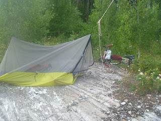 |
| Basic accommodations along the trail... |
I stopped by the Bed and Breakfast to let them know that I
had returned, but no one was about, so I left them a “thank-you” note. I packed
up the car and headed out towards Duluth, Minnesota…I was home at 3:00 a.m.
with time to spare… It had been a great adventure!


